30 Sep New Structure Plan for Frankston City Centre
The second amendment of the Frankston Metropolitan Activity Centre (FMAC) was approved last month. This follows a two year process, including a panel hearing to consider submissions back in February 2018.
The amendment known as C124 focuses on rezoning Areas 1-5 of the Frankston Metropolitan Activity Centre Structure Plan. The changes include rezoning the area around the Arts Centre to Residential Growth Zone and rezoning the areas around the Frankston Central Activity District and along Nepean Highway to the north as a Mixed Use Zone. The existing Design and Development Overlay (DDO) has also been replaced with new DDO schedules to reflect the building and design guidelines that were adopted as part of the Structure Plan.
The completion of this Amendment supports the future plans for Frankston that were first envisaged with the Structure Plan and allows for more consistent development and decisions moving forward. The Amendment also fixes the issue that while housing was being encouraged it was prohibited under the planning controls in some areas.

Amendment 1 of the Frankston Metropolitan Activity Centre
A structure plan for the Frankston Metropolitan Activity Centre (FMAC) was approved in May 2015 and the first planning scheme Amendment has been undertaken. I have had a number of recent projects and enquiries within this area and so I thought I would take a closer look at the Structure Plan.
What area does it cover?
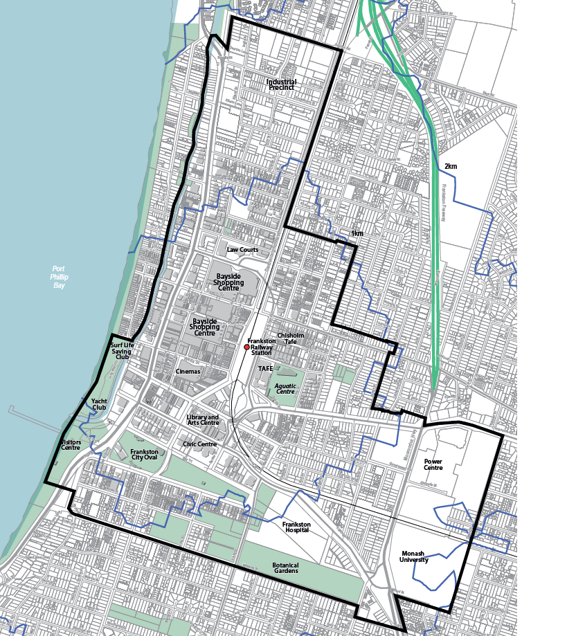
The Frankston MAC extends from Overton Road in the North to Williams Street in the south. The western boundary is initially Kananook Creek and then it extends to the foreshore around the Surf Life Saving Club. The eastern boundary is initially Dandenong Road West and then the boundary extends further east, including the area around Chisholm Tafe and the Frankston Power Centre and Monash University.
Here is a map of the area:
What is the purpose of the Structure Plan?
In a nutshell the purpose of the structure plan is to direct the growth and development of the area.
The area is divided up into 13 precincts with objectives, building height limits and setbacks specified for each precinct.
I will look more closely at two areas: the area known as the Ebdale Precinct and the Frankston City Centre and Foreshore area.
Ebdale Precinct (Precinct 4)
The vision for the Ebdale Precinct is “an attractive, well-planned residential neighbourhood offering a diversity of housing choices for people to live close to shops, jobs, transport and the beach.” The objectives for this precinct are to provide increased housing density and diversity. The proposed building height limit for the majority of the precinct is 13.5m, with some transitional height limits proposed on the western boundary of the precinct where it interacts with the proposed increased height limits along Nepean Highway (Precinct 5 Nepean Highway Boulevard). See below for the building height limits for the Ebdale Precinct (the Precinct is within the red border).

This area is currently zoned Commercial 1, with a small number of properties zoned Commercial 2 and is constrained by Design and Development Overlay Schedule 6. These planning controls don’t fit in with the Precincts main focus for increased housing, and in the case of the Design and Development Overlay constrain the height limit to below what is envisaged by the Structure Plan. For these reasons a rezoning of the Precinct is proposed and should be a priority for Frankston Council. Rezoning the area to Residential Growth Zone has been proposed for the Precinct, but no Amendment has been prepared as of yet.
When I last spoke to the Strategic Planning Department of Frankston Council they recognised that this rezoning was a priority, and that work was underway. They were trying to get the Amendment started this year, but could not commit to this being achieved.
We are representing a client within the Ebdale Precinct at VCAT currently, against a Refusal at Council. As further learnings come from this project we will provide updates.
Frankston City Centre and Foreshore
This area is covered by the first Amendment proposed by Frankston Council to implement part of the Structure Plan. This Amendment (Amendment C123) comprises Precincts 1, 2 3 and 11 of the Structure Plan (covering the city centre and foreshore areas). The Amendment proposes to rezone the area within the Frankston City Centre to the Activity Centre Zone Schedule 1 and to rezone the Foreshore area to Public Park and Recreation Zone. The proposed rezonings are directly inline with the Structure Plan and will allow for the distinct land uses, building heights and setback controls specified in the Structure Plan to be implemented.
What is the vision for the City Centre and Foreshore?
Precinct 1 is the City Centre
The Precinct encompasses land from Nepean Highway to Young Street, including the Bayside Shopping Centre and cinema complex. The objectives of this precinct is to encourage housing on upper levels and improve connection and linkages between services, foreshore and surrounding residential areas.
Precinct 2 is Frankston Station
The aim of this precinct is to improve and upgrade the facilities to improve the function of the transport hub and improve safety.
Precinct 3 is Arts, Entertainment and Government Services
This precinct is split into two areas, an area directly to the north of the city centre which includes the law courts and an area directly to the south which encompases the Frankston Arts Centre and Frankston City Council municipal building. The purpose of this precinct is to strengthen arts, cultural activities, entertainment and government services within these areas, provide higher density housing and improve connections between the Frankston Arts Centre, City Centre and Station Precincts.
Precinct 11 is the Foreshore
The purpose of this area is to enhance Nepean Highway, Kananook Creek and the foreshore and to improve connects to and within the area.
Proposed Planning Controls
The proposed Amendment has specified preferred land uses, building heights and street setbacks for Precincts 1, 2 and 3, including a maximum height of 44m to the Station Precinct and 38m for parts of Nepean Highway on the shopping centre side. The proposed planning controls also provide for a graduated height with a 12m maximum height limit within 5m of property boundaries abutting key streets. Provision for solar access to key streets has also been identified within the proposed planning controls, with specified measures as to what level of solar access to these streets is to be provided.
The Amendment seeks to rezone the Foreshore to Public Park and Recreation. This is to recognise that development of this area is now complete and that it should now move into a “maintenance” phase. The proposed rezoning is in keeping with the zoning of other similar foreshore areas along the Bay and brings the area into alignment with other municipalities.
The proposed Amendment has been exhibited to the public and a panel hearing has been requested which will consider all submissions that have been received. From there the Council will decide how to proceed (whether to make any changes to the Amendment, proceed without changes or abandon it) and then submit the decision to the Minister for Planning. It is unlikely that this process will be completed until well into 2017.
The Structure Plan provides a comprehensive vision for Frankston City Centre and will guide future development. Hopefully other Amendments, such as to the Ebdale Precinct will follow suit shortly to allow for the whole region to be comprehensively redeveloped.